This part of Canyonlands is the northern part accessible from Moab, not connected by any roads to the southern part called "Needles" area. I much prefer this one, since it's fantastic scenery. And it's very diverse, since the road to the main part of the park was mostly rolling hills with greenery on them.
Monday, August 31, 2015
Canyonlands National Park - Island in the Sky
This part of Canyonlands is the northern part accessible from Moab, not connected by any roads to the southern part called "Needles" area. I much prefer this one, since it's fantastic scenery. And it's very diverse, since the road to the main part of the park was mostly rolling hills with greenery on them.
Saturday, August 29, 2015
Scenery around Moab Utah
This photo, and the one below, are my views where I've been staying in Moab. It's on BLM land, no hookups, but the scenery is spectacular. I have no idea how high this wall is, but it's across the Colorado River from my camp.
The other photos below are ones I took on a couple scenic drives around the area.
Monday, August 24, 2015
Moki Dugway and Gooseneck State Park, Utah
I was on my way to Gooseneck State Park on a two lane road when I saw a couple of these warning signs. I had been warned about this 2 mile stretch of this road and it's actually marked with a warning on the Utah map, although not on my road atlas.
These people were not kidding about this road, I went down it in first gear. In places, the road was not wide enough for two vehicles to pass. There were no guardrails, even though it was a straight drop. On the inside, there were places where the road washed out and there was at least a foot or two drop. It would not be pleasant to run off the road here. There were some areas where you could pull off and take photos. A couple of the severe switchbacks were actually paved - years ago.
This road was built so you could get down from a mesa to the valley floor, shown above. Below shows one of the switchbacks that had a nice parking area to get out of traffic. I think some people on the road took the trip just for fun.
Finally, I was back on flat land......
I continued on to Gooseneck State Park, named for an area where the San Juan River runs through and created a canyon. In a distance of 1.5 miles, the river meanders 6 miles curving around. The river is 1000' below the canyon rim and it's an impressive sight.
Below are a couple more photos, and the last one was a mountain on my way home - I thought the zig zag color was interesting.
Needles Overlook, Utah
Church Rock rises out of a field of relatively flat land. It sits there all by itself, with no other rock formations close by. Mountains can be seen on the distant horizon. It is a bit strange to see no other sign of rock formations nearby.
Needles Overlook is reached by a two lane road through an area with red rocks emerging from the earth in the middle of fields of sagebrush. Large red rocks worn smooth by erosion seem to rise out of the earth with no rhyme or reason.
At the end of the lonely road, a sign announces Needles Overlook. It is a massively different terrain than the one I've been traveling through. As I get out of the truck, I see the floor of what looks like a canyon far below, stretching all the way to the horizon. At the horizon I barely see parts of the Colorado River, with mesas behind it. It's a breathtaking sight. Unfortunately, we had been having hazy weather so it wasn't as clear as I'd hoped. I can only imagine if the air was clear, all the colors would be more dramatic. As it was, I was certainly impressed.
Utah certainly is amazingly colorful, and there is more to come. Next week, I'll be exploring red rock arches towering over the landscape.
\
Natural Bridges National Monument, Utah
This monument includes three natural "bridges" of stone, which are different from arches in this area. The bridges are made from erosion through the years by water moving through the rock. Arches are made by other types of erosion.
In order to actually see these bridges up close, you have to hike down to them. Otherwise, you're standing there on the overlook and seeing a rock area with trees and other plants. On occasion, the bridge just blends into the other rock areas. Still, it's a beautiful area, with lots of canyons and rocks worn through the years. You can see the arch below, behind the trees in the middle of the photo.
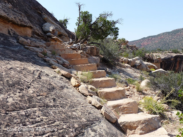
I elected to hike down to the second bridge, it was labeled as "strenuous", but they've timed it at 1 hour round trip. Going down into the canyon is the easy part, gravity really helps. Most of the trail consisted of steps either carved into the rock walls or made and cemented in place.
In a few places they had guardrails to hold onto because the rock was very steep, even when steps were carved into them. In one place, there was a small ladder.
When I finally arrived at the canyon floor and walked over to the arch, it was massive and very impressive. It was red rock, arching over 200' over my head and spanned 200 feet from side to side. The canyon floor at that point was full of rocks and water still flows through the arch, as evidenced by some standing water off to the side.
The next arch was totally different and as you can see by the photo below, it pretty much blends into the scenery.
I wasn't planning on hiking down to this one, since the hike up from the canyon floor was hot and I'm still having trouble with the high elevation and lack of oxygen. However, it wasn't that far and it was labeled only "moderate", not strenuous. So, I decided to go for it. It was impressive when I got down the trail, but I liked the red rock one better. This one is only about 100' high, and the span was only 180'.
Most of the rest of the scenery looks typically like the photo below - canyons shaped by water, wind and time.
Sunday, August 23, 2015
Abibliophobia
I have read lots of books all my life and I will confess to having a certain level of abibliophobia. The term defines someone who has a fear of running out of books/reading material. I've always used the library, although I now download 99% of the books I read from my former-home library. I will sometimes pick up a book at a book swap that I haven't read, but not often. When I was planning on living and cruising on a sailboat, one of my fears was that I would run out of good books to read. I spent lots of time gathering books to be read on my trip to the islands. While I was out there cruising, I would attend every book swap and also swap with other cruisers as we met them. I had such a great selection that when I sold my boat in Venezuela, I had to leave them on the boat. I knew I'd have a library where I was going.
I now spend time in libraries to use the internet, and the one shown above in Bluff, Utah is one of the most unique. The building was formerly the jail and has been repurposed as the town library, which is open only 2 days per week, for a total of 12 hours per week. It consists of one room and a friendly librarian full of information about the area. The wifi there is probably among the top few I have had to deal with. I've been in larger cities with larger libraries that didn't have wifi that good.
I certainly appreciate all the libraries I've visited and that I'll visit in the future. It sure makes life easier for me.
Saturday, August 22, 2015
Newspaper rock
There are multiple sites in the southwest called Newspaper Rock, this one is on Route 211 headed to Canyonland. This rock has more petrogyphs than a couple of the other ones I've seen. It dates back to some of the early settlers about 1300 or earlier.
Not all of these symbols have been translated, since we have no other records. Just for fun, I'm posting the following petroglyph because I know someone will think they're alien beings. I'm not sure what the little antennae on their head are - possibly some large bug?
In keeping with the silliness, I'm sure the following photo was their record of deer or elk, but when I saw them in line, my mind flashed on Santa's reindeer.
There are other things that are puzzling, the round ones that look like wheels, and there's one that looks like a ladder. And what's with all the wavy lines? One can only imagine, we'll never know for certain.
Thursday, August 20, 2015
Canyonlands National Park, Utah
Canyonlands is accessible from the southeast or from the north, many miles away. The park encompasses over 500 square miles of land, a large part of it is inaccessible. The Colorado River meanders through the eastern portion, although not visible from most of the improved portions of the park.
These rocks are sandstone and look as if they had been sculpted.
The area I visited consisted mostly of huge rock formations - again, think the size of big buildings - although off in the distance, through the haze, I could see large colorful mesas. I will be visiting the larger, northern portion of the park when I move further north. I'm looking forward to that, since it's a larger accessible area, and there is more to explore. In the meantime, I hope you enjoy the view.
Subscribe to:
Posts (Atom)