Thursday, September 11, 2014

Bandolier National Monument, New Mexico


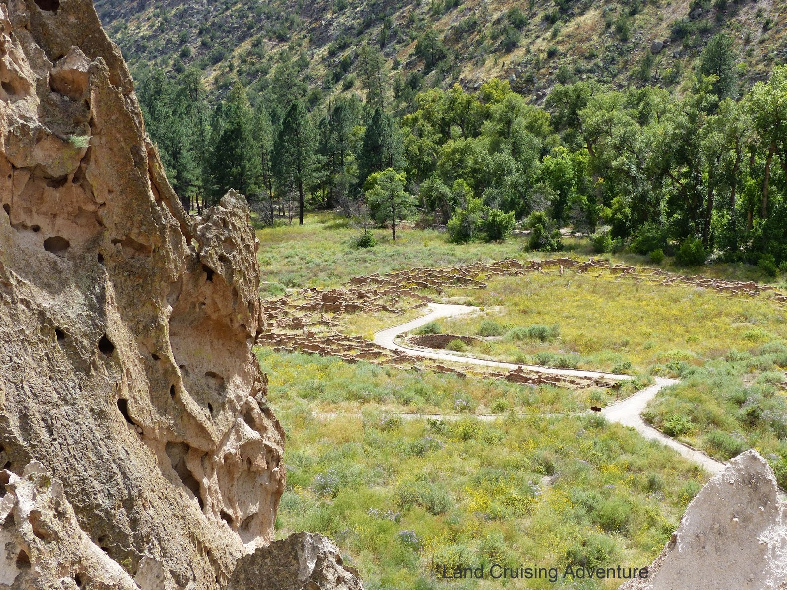
This site covers over 30,000 acres and is full of 12th century cliff dwellings, as well as ruins of adobe dwellings.  There are major cliffs in this area, created by a major volcano eruption over a million years ago.  The many holes of various sizes were caused by erosion.  The Indians in this area enlarged some of the holes for their homes by carving out larger areas. 
In the main area, the cliff dwellings were quite low and reached by walking up a hill and climbing a ladder with possibly a dozen or so rungs.  There are also circular ruins in this area left over from some pueblos built in a field, along with a large Kiva, which was a religious shrine.  They may have been similar to the ones in the first photo above.
 
On the sheer cliff wall, there were many petroglyphs of animals and circles, although it seems that they have faded with the weather.  More evidence of former homes is nearby.

About a half mile hike through the forest area is the Alcove House.  This is a shelter high up on a cliff which is reached by multiple ladders as well as steps built into the cliff.  The sign says that it’s 140 steps up the face of the cliff.
 
After a bit of contemplation, I decided I really needed to climb up to the top, since I came all the way to see it.  Actually, it wasn’t that much worse than climbing ladders to a sailboat sitting in the haulout yard.  Just way more steps to each ladder, of which there were 4.  In the photo below you can see  other ladders in the bottom left. 
 
 
The view from the shelter was great.  It was up about the equivalent of a 14 story building and I was looking at all the tall pines way down at the bottom of the canyon.


The round stone structure is another Kiva, which had been refurbished since it was excavated in 1908.  There were also a few small caves carved out on the sides of the main shelter.
 
For anyone who might be in the area, it's a great trip.  And for avid hikers, I understand that there are about 70 miles of trails.  Some may require an overnight stay.  
 

Tuesday, September 9, 2014

Tent Rocks, New Mexico (aka Kasha-Katuwe)


Cochiti Lake Park is run by the Corps of Engineers and very closeby is a National Monument called Kasha-Katuwe, more commonly known as Tent Rocks. Yes, another area of rock formations, different from other areas I’ve hiked. These rocks are shaped, for the most part, like Indian teepees. Some of them have boulders perched on the top.


There are two trails in the park, the more difficult one was a mile and a half to the top. I decided to do the difficult one first since it included a canyon slot, climbing rocks and an increase in elevation of over 600’, which was mostly during the rock climbing area. The canyon slot was very interesting, a trail between boulders that are the height of buildings at least 4 stories tall. The trail through this area may be as close as 2-3’ and then it opens up into wider areas 20’ or more in other places.


Then, suddenly, you exit the canyon slot into an open area with more rock formations towering over even the highest pine trees. The trail continues with a slight incline and a few rocks to climb over. Soon, the trail is littered with boulders to climb around or over and it becomes steeper.


When the trail finally levels out, it’s on the top of the mesa with mountains on all sides. The day was clear, so there was a great view of the mountains.


The downhill hike was so much easier since gravity helps. It took me much less time coming down than going up, besides I had already taken most of my photos. By then, the light had changed and I got a different perspective on the formations.


I hiked the other trail, a very easy walk through the lower part of the park near some of the rock formations. It was not as dramatic or impressive as the other trail, but way less strenuous. Great exercise for the day, with both trails, I walked/climbed about 4 miles. 


Monday, September 8, 2014

Riding the Rails - Cumbres & Toltec in Chama, New Mexico

 
While I was staying at Heron Lake State Park in northwest New Mexico, I visited Chama, about 10 miles north of the park. It’s a small tourist town with the main draw being the Cumbres & Toltec Railroad. This is a narrow gauge railroad that was built in 1880 and in 2012 was designated a National Historic Landmark. I walked around the train yard, took some pictures of the trains in the yard and picked up a brochure. I’d never been on a train and I had been told the trip went through some beautiful country.


The next morning, I drove up to Chama and got my ticket. It’s a one way trip on the train, so they drive the passengers up to Antonito, Colorado to start the trip. Everyone had assigned seats, but the train was not crowded and we could stand in the open car to take pictures or just see the scenery. It was a beautiful day, so I spent most of my time in the open car. It was a bumpy ride and I wasn’t sure how the photos would come out, but I was surprised that they were decent. The locomotives are run with coal, chunks larger than a softball, which creates black smoke out of the smokestack.


We started the trip in Colorado and on the way down to the depot in Chama, we crossed the state border 11 times, yes - eleven. The track snakes around the mountains and each time we crossed the state line, there was a sign stating "Enter New Mexico" on one side and "Enter Colorado" on the other. There were many dirt roads through the desert part and each time they crossed the tracks, there was a railroad crossing sign. It was near one of those signs that we saw a herd of deer run across the tracks in front of us. Unfortunately, the only photo I got was of the back of them running away.


When we got to the mountainous area and we had to pass through the narrow openings they blasted through the rock, the train slowed so that the vibration of the train passing through the rock walls would not dislodge any of the rocks. In some of these areas, the rock walls were so close we could have reached out to touch them. In other areas, trees were also close. There were two tunnels, and after the second one, the track came out right on the side of a large gorge that dropped 600’ - a very dramatic exit from the darkness of the tunnel. There were numerous trestles, the highest one was 137’ over a creek. The highest elevation the tracks reached was over 10,000’.


Halfway through the trip, we stopped for lunch, which was included in the trip, and served cafeteria style. We had a choice of turkey dinner or meatloaf – turkey for me!  After that, we boarded the train for the second half of the ride back to Chama. 


It was a fun day and I’d recommend the trip to anyone who is in the area. The scenery is gorgeous with rolling hills, rock formations, valleys far below us and open fields with little rivers coursing through them.


One of the men working on the train as a docent was a volunteer and said that anyone could be a volunteer by becoming a "Friend" of the railroad. Details can be found on their website at www.cumbrestoltec.org


Wednesday, September 3, 2014

Abiquiu Lake Park

 
I just spent a week in a park run by the Corps of Engineers.  This park has some of the most gorgeous scenery, both inside and on the roads leading to the park.  This is red rock country, an area made famous by the paintings by Georgia O’Keeffe, who lived in the area for decades.  There is more information and photos about this area in my two previous blogs.
 
 
The camping areas all have views of the lake, and I had a great view, especially sunsets.  


The little town, about 8 miles away, consists of an all-purpose store/restaurant/gas station, a tiny post office, some art galleries and an old adobe church, founded in the 1800s, that has been kept very nicely. 
 
 
The most famous formation in the area is Cerro Predernale, can be seen from all over, and is very visible from the park.  It has appeared in many photographs and various other art work. 
 
 
Although the lake is cold, since it’s about 6300’ up in the mountains, I did see a brave person water skiing on the lake.  I met quite a few people who had been fishing, but no one admitted to catching anything worth keeping. 
 
 
 It was a great place to spend a holiday weekend, and I definitely would visit that park again.


Sunday, August 31, 2014

Plaza Blanca, New Mexico

 
Plaza Blanca isn’t a town or even a crossroads.  It’s an area off a remote dirt road that is full of rock formations and towers.  Instead of the red rock that is so prevalent in this area, this is more a light concrete or sand color.  Whatever the color, it’s a very impressive area.  The area was all off-white color, except for rocks of all colors that had washed down from somewhere above, they were scattered over the entire area, adding contrast.  Someone had even arranged some of them into a spiral formation.
 
 
 I hiked all over the area and followed a gully that would have been a river had it been rainy season.  It turned into a miniature canyon and I followed it until it was just a little stream coming down from the rocks further upstream.  I kept seeing dog footprints, and then I realized it was probably a coyote.  Then I kept looking for a coyote, but didn’t get to see one.  I did get to hear a few of those when I stayed at a campground that was in a canyon.   I did see the cute little critter in the photo below.
 
The area was quite large and a bit spooky since I seemed to be the only person in the area.  There were no noises except for the occasional bird call and except for the cute lizard, the only other critter I noticed was a tiny frog about an inch long, and he blended perfectly into the sand that had washed down from above and was brown shades. 
 
Further on into the gully area were some large trees which have been hanging on for years during the rainy season and they seemed quite healthy. 
 
 
After an hour and a half of wandering around these amazing structures, I decided it was time to get some lunch.    


Friday, August 29, 2014

Ghost Ranch, New Mexico

 
Ghost Ranch is a retreat as well as an art colony - they have classes on pottery, painting and other arts.  They also have numerous hikes for day visitors as well as resident students or other visitors.  Since they serve meals to residents, they also have a farm where they grow their own vegetables and flowers.  While I was there, I noticed a really pretty flower (so I thought), with purple plumes.  It’s not really a flower, it’s a type of grain similar to wheat or millet. 
 
 On the drive up to the complex, I passed a rustic cabin complete with a stone chimney on the outside and a fenced area in back.  I found out later that it was built for the set of a movie back in the 1990s – City Slickers.  They did a great job of construction since it looked like it could have been a couple centuries old.  I was a bit disappointed that it wasn’t ancient.
 
I elected to do one of the hikes, one of the more strenuous ones.  The trail is only 1 ½ miles to the top, but to get to the top of the trail, you have to climb over 600’ of elevation in that distance.  I was thinking on doing a less strenuous one, but I decided I shouldn’t wimp out – and besides that hike would give me some great photos.  It was the climb to the Chimney Rock.  The photos below show the rock at about halfway up the trail and then at the top of the trail.  The trail leads to the mesa next to the Chimney Rock, so the photo is from the back of it.  Luckily, I had a liter bottle of water with me, and drank most of it.  The weather was great for hiking, cloudy without being overcast and there was a breeze for most of the hike.  The temperature was probably about 80-83 and not much humidity.


In the end, I’m glad I decided on that hike, and there were great views, such as the one below, coming down the trail – it was a long way down.


Tuesday, August 19, 2014

Taos Pueblo, New Mexico


 This Pueblo is inhabited by the Red Willow Indians and is known as the Taos Pueblo.


This is only a portion of the main northern structure, which has been inhabited continuously for over 1,000 years.  Some of the homes have been converted into shops for tourist trade while others are still used as homes.  There is a restriction on electricity or running water within the village.  Homes have little fireplaces and some have wood stoves for heating or cooking.  The walls are at least a foot thick and keep the inside cool in summer and warmer in winter.  A large quantity of homes are in this complex - homes are built side by side, sharing common walls, ceilings, etc.  Individual homes are anywhere from 1 to 3 rooms.
 

The construction is adobe brick, which consists of dirt, straw and water formed into bricks.  They are dried and then stacked with more adobe mixture between them.  The structure is then plastered with more adobe mixture.  As it ages, the straw shows through.


The majority of the population is Catholic, but the native culture and way of life is evident in the total population. 

 
The photo below is a shot of a couple Kivas, which are their sacred religious shrines.  This area is off limits to visitors, and they are underground, with sticks marking the entrance.
 
 
The photo below shows a typical house with the ladder to get to the roof and a bunch of dried chiles hanging on it.  Entrances were through a hole in the roof in the early days and ladders were needed to get inside.  In order to help protect themselves from invasion, they would just pull the ladder up on the roof.  


Most of the homes have only one oven, this one has two.  An oven is called horno and they are still used, especially for large quantities of food.  Wood is used to warm up the oven, then the food is put in.  The pieces of board in this photo just cover the opening.


The cemetery is sacred and no one is allowed to enter unless there is a funeral.  This is why it looks unkempt, they do not maintain it because they would have to enter it.  The ruins within the walls of the cemetery are the church that was damaged by US troops in the 1800s

 
This area was fascinating and I walked through the area at least twice.  They have several shops that open during the morning, with all sorts of goods for sale, including beautiful native pottery, jewelry, paintings.  There are also baked goods for sale, including fry bread, oven bread and cookies.  I had to try the fry bread, which was pretty good with cinnamon and sugar on it.


Saturday, August 16, 2014

Enchanted Circle


I took a trip around the Enchanted Circle, starting and ending at Taos, New Mexico.  This circle of roads goes around some of the ski areas of northern New Mexico, thereby allowing for great scenery and a fun day trip.

I started early in the morning and drove north into the Carson National Forest.  I kept stopping at different areas to take photos.   The first town on the way was Questa, which wasn’t much of a tourist destination, but seemed like a nice little town.

Moving along, the roads were good and not at all crowded, and took me up to almost 8700’ and the ski resort town of Red River.  This area was very crowded due to a chili cookoff/music festival this weekend.  The main street  is situated between 2 mountain areas and is a very touristy place.  They make use of the ski lifts during the summer by giving rides up to the top at 10,000’.  I was feeling the effects of lower oxygen saturation, but I walked around town for a while, checking out some of the shops.

My next stop was Eagle’s Nest, a smaller town, and less touristy.  I had lunch there in a little restaurant that had all sorts of memorabilia for decorations – ice skates, vintage hub caps and chrome car names on the walls.  There were a few old license plates and a traffic stoplight in the corner. The menus were glued on old music LPs.  After lunch I went into a little shop that had a variety of rocks, minerals and crystals for sale.  Very pretty stuff, and some of them are priced anywhere from $5 up, mostly up.  I’ve seen some that are priced in the hundreds. 

The weather in this area was very pleasant – sunny, with a few clouds and about 75, with low humidity – just right for running around without AC in the truck and walking around these towns. 

On the way to the next town, Angel Fire, another ski resort, I stopped at one of the state parks and took the photos shown below. 


The prairie dogs are plentiful in this area.  They will stand by the side of the road or run across the road even with vehicles coming by.  I tried to get some good photos of them on the trail to the lake, but they wouldn’t come out of their burrows.  I got this photo at the last little town I stopped at today.
                        
Coming home, the roads were mostly downhill and very twisty, with lots of turns and brought me down to about 6700’, where I’ve been staying.  Along the way, I had to stop and take photos of a cute little house – a bit of a fixer-upper.  Check it out……